Hiking Pico
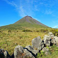
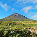
Ever since our arrival on the central group of the Azores, the volcanic mountain of Pico has been spurring our curiosity. It is located on the second biggest Islands of the Azores, named after it. With an altitude of 2'351m it is not only the highest peak of the Azores, but also the highest mountain of Portugal. Since there have been volcanic eruptions and severe earthquakes in the last 400 years, a lot of people left the place and it's now mostly populated by cows.
With no harbor for sailing boats on Pico and only ten miles from our current position, we decided to go there by scooter and ferry. Because there's a limitation of visitors of the volcano of 200, the ranger we talked to on the phone told us to be there around 8 am. So, we already spent the night before the big event in a hotel on the island, got up while it was still dark, looted the hotel's buffet and drove off toward the mountain cabin, where the trail starts. When we arrived before 8 am, there were already cars turning back. Hundreds of peopled had waited to take the hike – due to it being the first nice day in two weeks. We couldn't believe it – but had no other choice than to put our names down on a waiting list (place 73). Since each hiker must carry a GPS device which was provided by the rangers, we could follow the progress of each one on a big screen. The wait was painfully long and frustrating. Time and again we calculated the hours we had left – we had to catch the 6pm ferry and had been told that the hike would take 5 to 7 hours...
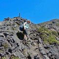
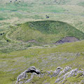
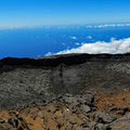
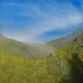
Finally, shortly after noon, we were permitted to head off. The sun was already at its peak and burning down on us and the black lava rocks. The trails lead on a direct and steep course towards the first crater. The walking on the petrified lava rivers is quite easy thanks to the sharp and firm rocks. Our only concern were the little lava tunnels, which we met on our “shortcuts” - they are small tubes, their surface only a couple of millimeters thick – in some places already broken. The farther we went, the steeper the trail got and we were very happy to wear the high hiking boots. As always, we met some strange hikers, walking in sneakers – or rather quite frightened ones, going on hand and feet – no surprise hence, that some needed more than 8 hours.
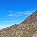
But then for us it was quite strenuous and the sweat was running continuously in the hot sun. Usually, the peak is shrouded in thick clouds – but not this time. Thanks to the low humidity, an excellent outlook allowed us to spot all the central islands. To our relief, it only took us two hours to ascend, so we were optimistic to be able to catch the ferry on time. Nevertheless, we went down at a fast pace; we made the 1'200 meters of altitude in a light trot – acknowledged by protesting legs when we arrived at the starting point 1.5 hours later. The remaining time we spent in a natural seawater pool to relax our sore muscles and by replacing the water we had sweated out in a neat cafe near the ferry dock.
São Jorge
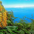
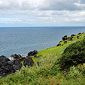
Thanks to our sour legs, we spent the next couples of days around the boat with a lot of snorkeling and some minor works. Only four days later, our muscles permitted the first short hikes and we started to discover more of the steep, amazing and evergreen north coast on old and unofficial trails.
Unfortunately, the time had come to head towards our “winter camp”. We had decided to leave our Happy Day on the small and most southern island of Santa Maria – almost 200 nm to go. The weather forecast promised strong and constant northerly winds – just perfect to head southeast. With the help of seven other sailors and the marina staff (uff…) we managed to leave the small marina – each one holding a line and leading our boat through the narrow alley and around the sharp bends.